Trails and Guidelines
The Simpson Hill Wilderness Trail Network was conceptualized by Tim Foulkes, for the love of nature. With the help of family and friends, and for the endless enjoyment of canine companions, it took shape over the course of 30+ years.
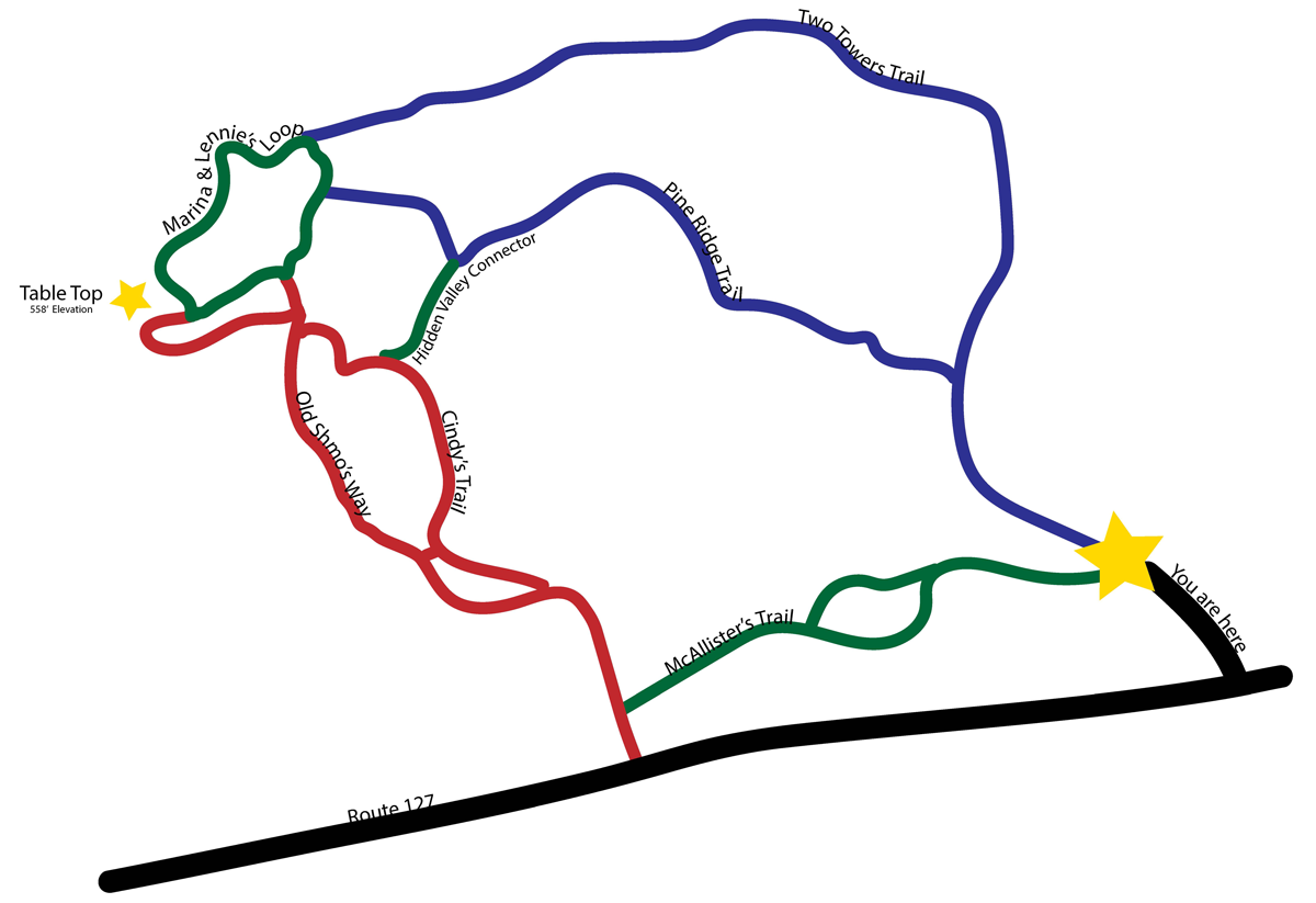
Table Top (at 558 feet) offers spectacular views of the St. Croix River, Oak Bay, Waweig River and environs. Soak up the wonders of nature in your adventure on Simpson Hill. For geocachers, check CGNAVV to find Karen’s Cache. Trails have reflective diamond-shaped markers:
Green (Easy) Trails – Less challenging, flatter terrain
- McAlister’s Trail (.45 kms) – Parallels Rte. 127. Can be wet depending on season
- Marina & Lennie’s Loop (.64 kms) – Several trails join this loop near Table Top
- Hidden Valley Connector (.15 kms) – Mossy valley hike to connect Pine Ridge and Cindy’s trails
Blue (Intermediate) Trails – Longer routes than red, therefore more gradual inclines
- Two Towers (1.13 kms) – Gravel road to water towers, then old woods road growing up in young trees
- Pine Ridge (.76 kms) – Starts on Two Towers Trail (gravel road), diverges to an old woods road, then up along a ridge with old white pines
Red (Difficult) Trails – Steeper climbs, take time to catch your breath and look around
- Cindy’s Trail (.66 kms) – Cross power line, then follow right side of stream, and steady upward climb gradually bearing left (north) toward Table Top
- Old Shmo’s Way (.77 kms) – After power line, hike along ridge, cross small stream and get nice view from the “U” tree, before reaching Table Top
- (Both Cindy’s Trail and Old Shmo’s Way are accessed by McAlister’s Trail (green)
Guidelines for Simpson Hill Visitors
Various routes – depending on your need to explore, it is about a 30 minute climb to Table Top, at 170 M ASL, by the shortest route. The trail map gives an overview of the trails, not to scale. Table Top is an open rocky bluff with spectacular views of the St. Croix River, Devil’s Head (Maine), Todd’s Point, Oak Bay, Hill’s Point and the lower Waweig River. Marina and Lennie’s Loop trail provides views eastward of the Chamcook Lake watershed from Rollingdam to Bocabec.
Trail standards – are of the “low use, back country” type that highlight natural features. Rocks and lichen can be especially slick in damp/wet weather and pine needles can be slippery in dry weather. Hiking shoes, not sandals, (or snowshoes in winter) are recommended! See the Trails section for details on relative degree of difficulty.
Trail markers – reflective diamond markers in blue (easy), green (medium) or red (most challenging) show designated trails. Blue trails are often “laterals” cutting across to link the main up/down routes.
Walking sticks – highly recommended and may be available at the trail head. They aid you climbing and really ease the knees coming down.
Respect – the natural dams and pools on the stream. They hold water during dry spells and make beautiful “falls” in wet weather. Also, the stone cairns that have been erected as monuments and trail markers are often the only visible markers in winter. This is a “wild” nature park and we need your support to make it endure. It is litter free because people love it. We hope you do too.
Respect Simpson Hill
- NO FIRES
- CARRY IN – CARRY OUT
- Take only photos
- Leave only footprints
- Use CAUTION at Tabletop
For Your Safety
- Wear hiking boots (or sturdy footwear)
- Have adequate water
- Have appropriate clothing (layers)
- Have a flashlight
- Have bug repellent